SHIPPING QUOTE FOR OVERSIZED ITEMS MUST BE REQUESTED | WhatsApp Global CLICK HERE
$ 132.50 USD
Use to determine forest overstory density or as one indicator in wetland delineation work. Helpful...
Ver todos os detalhes do produto »
$ 195.00 USD
The Suunto PM-5 is a high-precision handheld clinometer designed for professionals who need to quickly and reliably measure vertical angles, inclines, and heights in the field. Used worldwide by foresters, surveyors, engineers, geologists, architects, and cartographers, the PM-5 combines a clear optical scale, a liquid-filled capsule for stability, and a lightweight, durable design made in Finland. It operates without batteries, making it ideal for extended outdoor use.
Specification | Suunto PM-5 |
---|---|
Glass Material | Acrylic |
Dimensions | 52 x 77 x 15 mm |
Weight | 94 g / 3.32 oz |
Battery Required | No |
Tripod Mount | Yes |
Conversion Tables | Cosine 0–45°, Cotangent 0–45° |
Operating Temperature | -30 °C to +60 °C / -22 °F to +140 °F |
Clinometer Scale | ±90°, ±150% |
Inclination Accuracy | 1/4° |
Resolution | 1° and 1% |
Adjustable Optics | Yes |
Liquid-Filled | Yes |
Bearings | Dual sapphire |
Country of Manufacture | Finland |
Ver todos os detalhes do produto »
Request Quote
The CI is the ideal instrument to measure the inclination of trees, buildings, walls, tunnels, roads, etc. Any field professional will appreciate the CI's simplicity and accuracy. Simply point and press the button, and the angle will be presented to you.
specs | |
---|---|
Dimensions | 20 x 63 x 44 mm |
Weight | 50 g |
Temperature | Min -15 ° Max 45 ° C |
Drums | 1 x 1,5 V AA alkaline. warning when low |
Display | LCD, backlit |
Consumption | 15 mW |
Angle | -55˚ < angle <85˚. Resolution: 0,1˚. Precision: + -0,2˚ |
(DR 20220822)
Ver todos os detalhes do produto »
$ 1,595.00 USD – Vendido
This product is sold by BIOWEB just to use into United States
This revolutionary measurement device features an integrated tilt sensor which allows collection of diameter data at any point up the stem and also determines the height at which a specific diameter is reached. The Basal Area Factor (BAF) routine indicates “In” and “Out” trees for a full range of sampling factors. In addition, the status of borderline trees can be determined by entering a distance from a rangefinder (not included) into the Criterion RD 1000 through the input serial port or manually via the keypad.
A second output serial port allows for data transfer to an external data collector (not included). To improve measurement resolution at greater distances, use the included 2.4x magnifier. The in-scope LED display features variable brightness for easy reading in all lighting conditions.
Water and dust resistant, the unit also features a 1/4” x 20 thread mount for attachment to a monopod or tripod. Carrying case, lens cloth, neck strap, and manual included.
dendrometers
Dendrómetro Electrónico Mira BAF Criterion RD 1000
Ver todos os detalhes do produto »
$ 28.65 USD
This mirror sighting height gauge is great for teaching students how to quickly determine tree...
Ver todos os detalhes do produto »
$ 195.00 USD
The Suunto PM-5 hand-held clinometers are used all over the world by foresters, surveyors, engineers, cartographers, geologists, miners and architects and many others to measure heights, vertical angles and slopes quickly, reliably and easily.
Suunto height meter PM-5/1520 is an instrument for measuring heights, especially heights of trees, with great accuracy and speed. It can also be used to determine the angle of a gradient. The body of the instrument is corrosion-resistant anodized aluminium-alloy. The scale card runs on a special bearing in a hermetically sealed plastic container filled with a liquid which guarantees that it runs freely and stops quickly. The liquid will not freeze, retains full damping properties in working conditions and eliminates irritating scale vibrations.
When measured from distances of 15 m and 20 m, tree heights can be read straight off the instrument’s scales. The readings should be doubled when measuring from distances of 30 m and 40 m. The Suunto height metre can also be used to determine the angle of a gradient, the reading obtained can be checked in the conversion table on the back of the instrument.
- Accuracy 1/4°
- Graduation interval 0.5°
- Scale: slope ±90°, slope %
- Adjustable diopter
- Dual saphire bearing
- Liquid filled capsule for stable operation
- Anodized light-alloy housing
- Nylon pouch with belt-loop
- Lanyard
- 2-year warranty
- Made in Finland
Ver todos os detalhes do produto »
$ 2,145.00 USD
The Haglöf Laser GEO Hypsometer features a unique combination of high-precision laser, ultrasound, and integrated GPS, compass, and tilt sensors for accurate 3D measurements. Results are displayed on an integrated data screen and an external graphic display.
The Laser Geo instrument is a high-precision laser rangefinder with built-in GPS, compass, Bluetooth, and USB 2.0 for communication. Extreme precision, extreme utility!
Specifications | |
---|---|
Dimensions | 93x63x72 mm |
Weight | 243 g |
Battery and Power Consumption |
|
Communication | IR, Bluetooth® BLE 4.0 class 2, Spp (serial profile), pin code 1234, USB 2.0 / SSD drive. |
Temperature | -20 ° to + 45 ° C |
ULTRASOUND (Vertex Laser Geo) |
|
Height | 0-999 m Height resolution: 0.1 m |
Angle | -90 ° - 90 °. Unit: 360⁰, 400⁰ Degrees and %. Resolution: 0.1⁰. Accuracy: 0.1⁰ typical. |
Laser |
|
Area |
|
GPS |
33-channel high-sensitivity receiver. Supports GPS, Glonass, Galileo, QZSS. Built-in real-time correction with SBAS (EGNOS, WAAS, MSAS, GAGAN) Accuracy up to 2.5 m / 8.19 ft in open terrain. Satellite position prediction up to 3 days. Multiglobal satellite navigation system based on GPS (USA) / GLONASS (Russia) / Galileo (EU) / QZSS (JAPAN) SBAS Augmentation systems based on satellites: WAAS (USA) EGNOS (EU) GAGAN (India) MSAS (Japan). Built-in auto-generated orbit prediction (TTFF faster up to 3 days), built-in interference cancellation. Accuracy: automatic position 2.5 m CEP (circular probable error) (50% static 24h, -130dBm. Speed 0.1 m / s (50% at 30 m / s. |
Compass | Azimuth compass 0-360˚, resolution 0.1˚, accuracy <1.5 RSME˚. |
Classification | MIL-STD-810E. Polycarbonate glass-filled housing frame material, IP67, NEMA6, laser class 1, 7 mm (FDA, CFR21) Class 1m (IEC 60825-1: 2001). |
View | Yellow point target 1x magnification. |
Display | 100x60 pixel external LCD graphical display. Internal heads-up display. |
Data Format | Nmea or Ascii. IR, Bluetooth. |
File Format | CSV and KML (Google Earth). |
Memory | 2000 non-volatile data sets. |
Other Information | Adapter and monopod stick, 4 pieces (33-140cm). Aluminum transport/storage case. Please refer to the user manual for more details. |
Ver todos os detalhes do produto »
Request Quote
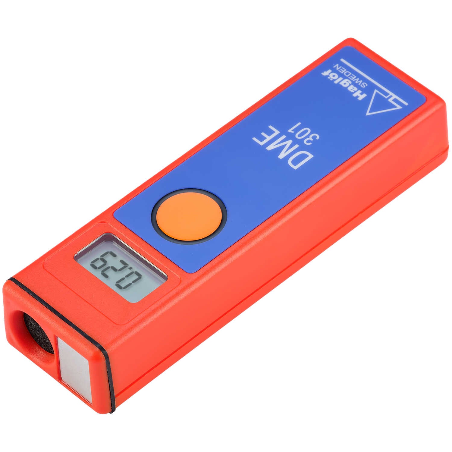
The DME 301 is the modern evolution of the reliable DME 201, widely used since the 1990s. This new version features advanced electronics, a graphical display, T4 transponder with LED indicators, and innovative functions such as BAF calculation and distance exceedance alerts. Thanks to its ultrasonic technology, the DME 301 provides fast and accurate readings even in densely vegetated environments. It can operate with a T4 transponder or alongside another DME 301 for a variety of applications including forest inventories, layout work, and road construction.
The T4 is the new and improved transponder replacing the T3 and all previous transponders. The T4 is equipped with six built-in LEDs that provide essential feedback:
The T4 is fully compatible with older measuring instruments, making it a perfect upgrade for all users. Introducing the T4 transponder—the future standard for all measuring instruments, including Vertex 5, Vertex Laser Geo, and DME...
DME 301 | |
---|---|
Battery | 1 x 9V alkaline battery |
Power consumption | 7 mA |
Operating temperature | -15 °C to +45 °C / 5 °F to 113 °F |
Ultrasonic frequency | 25 kHz |
Range | Up to 30 m (98 ft); with 360° adapter: up to 20 m (60 ft) |
Resolution | 0.01 m / 0.1 ft |
Accuracy | ±1% or better |
BAF factors | Variable from 0.0 to 999.9 |
T4 Transponder | |
---|---|
Size | 70 mm diameter (2.8") |
Weight | 85 g (3 oz) with battery |
Battery | 1 x 1.5V AA battery |
Power consumption | Max 9 mW |
Indicators | 6 LEDs for status and noise detection |
Compatibility | Compatible with Vertex 5, Vertex Laser Geo, DME, and earlier models |
360° Adapter | |
---|---|
Diameter | 58 mm (2.3") |
Height | 45 mm (1.8") |
Weight | 35 g (1.2 oz) |
Monopod | |
---|---|
Transport length | Part 1: 335 mm (13.2"), Part 2: 320 mm (12.6") |
Length in use | Min: 350 mm (13.8"), Max: 1390 mm (54.7") |
Weight | 335 g (11.8 oz) |
Ver todos os detalhes do produto »
Request Quote
The Laser Geo 2.2 Hypsometer offers precise 3D measurements thanks to its advanced technology combining laser, GPS, compass, and ultrasonic sensors. Ideal for professionals needing long-range measurements with easy data transfer to GIS applications. Its rugged design and long-lasting battery make this instrument an essential tool for fieldwork in any condition.
The 3D Vector function allows you to measure remote targets such as horizontal distances and angles between two points far ahead in the terrain, such as canopy width or river width.
3-point, 2-point, 1-point, or direct measuring – choose your preferred method using the easy-to-follow menu system. A nonmagnification dot sight helps identify individual targets such as treetops and power lines.
Use the built-in GPS to walk and log an area, or stand in the middle of the area and use the integrated GPS, compass, and laser to measure border points. View results directly in Google Earth or other geographic applications.
MAP wood chip piles.
The MAP TRAIL feature lets you gather target coordinates using laser methods, pitch, and azimuth data. Useful for mapping routes or planning forest cableway systems where GPS isn’t precise. The built-in compass continuously shows direction, helping you hit a target accurately.
Specifications | |
---|---|
Dimensions | 93x63x72 mm / 3.7×2.5×2.8” |
Weight | 243 g / 8.6 oz |
Battery and Consumption |
|
Communication | IR, USB 2.0/SSD, Bluetooth BR/EDR, Bluetooth LE V4.2 (LE), Spp (serial profile), PIN code 1234. |
Temperature | -20° to +45° C / -4°F to 113°F |
Height | 0-999 m/ft. Height resolution: 0.1 m/ft. |
Angle | -90° to +90°. Unit: 360⁰ degrees, 400⁰ degrees, and %. Resolution: 0.1⁰. Accuracy: 0.1⁰ typical. |
Laser |
|
Area |
|
GPS |
33-channel high-sensitivity receiver. Supports GPS, Glonass, Galileo, QZSS. Built-in real-time correction with SBAS (EGNOS, WAAS, MSAS, GAGAN). Accuracy up to 2.5 m / 8.19 ft in open terrain. Satellite position prediction up to 3 days. |
Compass | Azimuth compass 0-360˚, resolution 0.1˚, accuracy < 1.5 RSME˚. |
Classification | MIL-STD-810E. Frame material: glass-filled polycarbonate, IP67, NEMA6, Laser Class 1, 7 mm (FDA, CFR21) Class 1m (IEC 60825-1:2001). |
View | Yellow dot target 1x magnification (HUD) Heads-up-display. |
Display | External graphical LCD 100x60 pixels. Internal display (HUD) Heads-up-display. |
Data Format | Nmea or ASCII. IR, Bluetooth. |
File Format | CSV and KML (Google Earth). |
Memory | 2000 datasets, non-volatile. |
Other Information | Adapter and monopod stick, 4 parts (33-140 cm). Aluminum carrying/storage case. See the user manual for more details. |
Transponder T3 | Transponder T4 | |
---|---|---|
Size | Diameter 70 mm | Diameter 70 mm/2.8” |
Weight | 85 g | 85 g/5 oz (Incl. Battery) |
Battery | 1 AA 1.5V alkaline battery required for T3 | |
Power Consumption | 9 mW |
Ver todos os detalhes do produto »
Request Quote
Advanced Electronic Clinometer for Height, Distance Calculation, Basal Area, and Volume Estimation Measure heights accurately...
Ver todos os detalhes do produto »
Request Quote
Precision Electronic Clinometer with Distance Calculation Experience enhanced accuracy with the EC II-D, featuring rapid...
Ver todos os detalhes do produto »
$ 1,715.00 USD
The CCM-200 plus Chlorophyll Content Meter is an updated version of the very successful CCM-200...
Ver todos os detalhes do produto »
$ 25.50 USD
Hardened rubber cap is forged with extractor so it won’t work loose. Replacement parts are...
Ver todos os detalhes do produto »
$ 213.75 USD – Vendido
This device have been updated to the EC II - D and EC II -...
Ver todos os detalhes do produto »
$ 449.95 USD
Perfect for foresters, biologists, arborists, and other professionals who depend on reliable range and height...
Ver todos os detalhes do produto »
$ 215.00 USD
With premium optics and powerful distance measuring capability, the Prostaff 1000i 6x20 rangefinder will help you take more accurate photos. You will achieve precision of 1.8 m at a distance of up to 548 m, and the maximum range on a reflective surface is 914 m. The TRU TARGET technology allows you to choose between the nearest and farthest objects, which is very useful when measuring an object while other objects or obstacles are in view. The identification system provides precise distance measurement to an uphill or downhill target so you can choose the perfect remaining range. You can choose between spot readings or continuous measurement for up to 8 seconds, and if a spot measurement fails, you will automatically have up to 4 seconds of continuous measurement to capture the range.
Beyond its range capabilities, the Prostaff 1000i is a competent 6x20 monocular, with multi-coated anti-reflective optics for a bright, clear image. The body is ergonomically designed for a comfortable grip, the 16.7 mm eye relief is useful for users who wear glasses, and the control buttons are strategically located for easy use. With an IPX4 water resistance rating, this device is not afraid of a little rain or snow, and at just 9.1 x 7.3 x 3.8 cm, it easily fits into a pocket or backpack.
Specifications | |
---|---|
Measurement Range (actual distance) |
|
Accuracy | 5.49 to 91.44 m: 0.91 m > 91.44 m: 1.83 m |
Prism Type | Roof |
Magnification (x) | 6 |
Eyepiece - Effective Objective Diameter (mm) | 20 |
Eyepiece - Actual Field of View (°) | 6 |
Eyepiece - Exit Pupil (mm) | 3.3 |
Eyepiece - Eye Relief Distance (mm) | 16.7 |
Field of View | 104.25 m at 1000 m |
Dimensions (mm) | 9.1 x 7.3 x 3.8 cm |
Weight (without battery) (g) | 130 |
Power Source | CR2 lithium battery x 1 (3 V DC). Auto-off function (after approx. 8 s of inactivity) |
Laser Classification | Class 1M eye safe |
Ver todos os detalhes do produto »