SHIPPING QUOTE FOR OVERSIZED ITEMS MUST BE REQUESTED | WhatsApp Global CLICK HERE
a partir de $ 2,777.50 USD
$ 2,777.50 USD
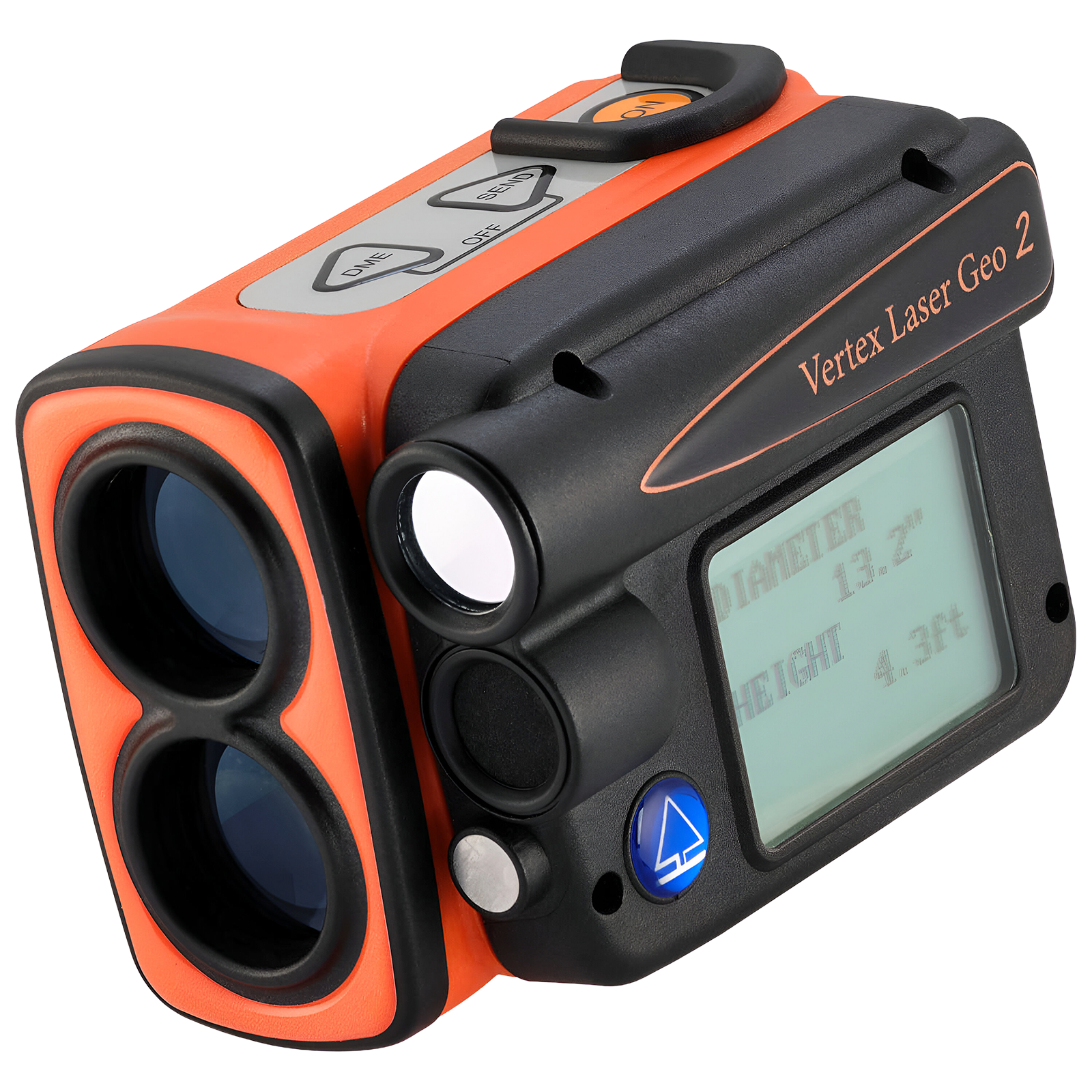
The Haglöf Vertex Laser Geo 2 combines long-range laser technology and ultrasound to provide accurate height, distance, and diameter measurements, even in dense or challenging conditions. With 3-axis tilt sensors, compass, built-in GPS, and connectivity options such as USB, Bluetooth, and infrared, it's an all-in-one tool for field professionals. Its programmable platform allows you to customize features and apps to meet specific needs.
Two vertical lines or
a single horizontal line.
The 3D Vector feature allows you to measure remote targets, such as horizontal distances and angles between two far points in the terrain, like canopy width or river width. Additionally, with the Vertex Laser Geo 2, you have the option to use ultrasound to measure distances in areas with dense vegetation and underbrush.
The MAP TRAIL feature allows you to logically collect destination coordinates using laser method, tilt, and azimuth data. It is useful for mapping trails or roads where GPS is inaccurate, or for planning a forest cableway system. The built-in compass continuously shows direction, guiding you to reach a target accurately.
The T4 is the latest and improved version of the Transponder, succeeding the T3 and all earlier models. Equipped with six built-in LEDs, the T4 provides crucial information at a glance:
The T4 is fully compatible with older measuring instruments, ensuring an effortless upgrade for users. Introducing the T4 Transponder, setting the new standard for all measuring tools, including Vertex 5, Vertex Laser Geo 2, Vertex Laser Geo, and DME...
Power | |
---|---|
Battery | 3.7V rechargeable Li-Ion, approx. 2000 measurements |
Power consumption | Max. 0.9W |
Charging time | Max. 3.5 h |
Communication and Storage | |
Interfaces | USB 2.0 / SSD, IR, Bluetooth V4.2 LE and Classic |
Memory | 2000 non-volatile records |
Formats | CSV, KML (Google Earth), NMEA or ASCII |
Measurement | |
Laser range | 46 cm – 700 m |
Laser accuracy | ±4 cm typical |
Ultrasonic range | 30 m (20 m with 360° adapter) |
Ultrasonic accuracy | 1% or better typical |
Angle | -90° to +90°, accuracy 0.1°, resolution 0.1° |
Height | 0–999 m/ft, resolution 0.1 |
Remote diameter | Up to 47" at 10 m, accuracy 1.2 cm |
GPS and Sensors | |
GNSS Receiver | GPS, Glonass, Galileo, QZSS with SBAS |
GPS Accuracy | Up to 2.5 m CEP |
Compass | 0–360°, accuracy <1.5° RMS |
Inclinometer | 3-axis, typical accuracy 0.1° |
Displays and View | |
Head-Up Display (HUD) | Integrated, 1x magnification |
Graphic display | LCD 100x60 px |
Construction and Environment | |
Durability | IP67, NEMA6, MIL-STD-810E |
Material | Fiberglass-reinforced polycarbonate |
Operating temperature | -20 °C to +45 °C |
Ver todos os detalhes do produto »
Request Quote
Transponder T4 The T4 is the new and improved transponder that replaces the T3 and...
Ver todos os detalhes do produto »
Request Quote
The Laser Geo 2.2 Hypsometer offers precise 3D measurements thanks to its advanced technology combining laser, GPS, compass, and ultrasonic sensors. Ideal for professionals needing long-range measurements with easy data transfer to GIS applications. Its rugged design and long-lasting battery make this instrument an essential tool for fieldwork in any condition.
The 3D Vector function allows you to measure remote targets such as horizontal distances and angles between two points far ahead in the terrain, such as canopy width or river width.
3-point, 2-point, 1-point, or direct measuring – choose your preferred method using the easy-to-follow menu system. A nonmagnification dot sight helps identify individual targets such as treetops and power lines.
Use the built-in GPS to walk and log an area, or stand in the middle of the area and use the integrated GPS, compass, and laser to measure border points. View results directly in Google Earth or other geographic applications.
MAP wood chip piles.
The MAP TRAIL feature lets you gather target coordinates using laser methods, pitch, and azimuth data. Useful for mapping routes or planning forest cableway systems where GPS isn’t precise. The built-in compass continuously shows direction, helping you hit a target accurately.
Specifications | |
---|---|
Dimensions | 93x63x72 mm / 3.7×2.5×2.8” |
Weight | 243 g / 8.6 oz |
Battery and Consumption |
|
Communication | IR, USB 2.0/SSD, Bluetooth BR/EDR, Bluetooth LE V4.2 (LE), Spp (serial profile), PIN code 1234. |
Temperature | -20° to +45° C / -4°F to 113°F |
Height | 0-999 m/ft. Height resolution: 0.1 m/ft. |
Angle | -90° to +90°. Unit: 360⁰ degrees, 400⁰ degrees, and %. Resolution: 0.1⁰. Accuracy: 0.1⁰ typical. |
Laser |
|
Area |
|
GPS |
33-channel high-sensitivity receiver. Supports GPS, Glonass, Galileo, QZSS. Built-in real-time correction with SBAS (EGNOS, WAAS, MSAS, GAGAN). Accuracy up to 2.5 m / 8.19 ft in open terrain. Satellite position prediction up to 3 days. |
Compass | Azimuth compass 0-360˚, resolution 0.1˚, accuracy < 1.5 RSME˚. |
Classification | MIL-STD-810E. Frame material: glass-filled polycarbonate, IP67, NEMA6, Laser Class 1, 7 mm (FDA, CFR21) Class 1m (IEC 60825-1:2001). |
View | Yellow dot target 1x magnification (HUD) Heads-up-display. |
Display | External graphical LCD 100x60 pixels. Internal display (HUD) Heads-up-display. |
Data Format | Nmea or ASCII. IR, Bluetooth. |
File Format | CSV and KML (Google Earth). |
Memory | 2000 datasets, non-volatile. |
Other Information | Adapter and monopod stick, 4 parts (33-140 cm). Aluminum carrying/storage case. See the user manual for more details. |
Transponder T3 | Transponder T4 | |
---|---|---|
Size | Diameter 70 mm | Diameter 70 mm/2.8” |
Weight | 85 g | 85 g/5 oz (Incl. Battery) |
Battery | 1 AA 1.5V alkaline battery required for T3 | |
Power Consumption | 9 mW |
Ver todos os detalhes do produto »
$ 1,024.25 USD
Blume-Leiss ALTImeter dendrometers accurately measure the height of trees by obtaining the angle of elevation...
Ver todos os detalhes do produto »
$ 2,250.00 USD
Models TruPulse 200X TruPulse 360 TruPulse 360R Measures Azimuth with TruVector 360° Compass Technology N/A Yes...
Ver todos os detalhes do produto »